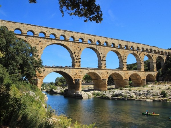
The Pont du Gard is a three-level Roman bridge-aqueduct, located in the town of Vers-Pont-du-Gard, near Remoulins, in the Gard department in France. It spans the Gardon, or Gard River, allowing passage of the Roman aqueduct that brought water from Uzès to Nîmes.
The Pont du Gard has been a historical monument since 1840. The Pont du Gard was added to the UNESCO World Heritage List in December 1985. It is the highest known bridge-aqueduct in the Roman world. It is a major tourist attraction in the Gard during the summer and is easily accessible by the departmental buses from Nimes, Alès via Uzès and Avignon via Remoulins.
The Roman aqueduct of Nîmes
The Pont du Gard is the monument that houses an aqueduct that spans nearly 50 km (49,702 m). It carried water from the Eure Fountain in Uzès near Saint-Quentin-la-Poterie to the Roman city of Nemausus, now called Nîmes. The spring water comes in part from the Alzon River, which passes through the vicinity of Uzès, and from water collected from Mount Bouquet, located closer to Alès. The aqueduct itself is a masterpiece of engineering, testimony to the extraordinary mastery of these ancient builders: the difference in level between the start and end points is only 12.6 m, with an average slope of 24.8 cm per km. Because of the topography, the aqueduct winds through the small mountains and valleys of Uzès and Nîmes.
The aqueduct of Nîmes was probably built in the first century AD, as attested by the ceramics. Tunnels dating from the time of Augustus had to be bypassed, indicating that the aqueduct was constructed later, and the coins found in the reservoirs of the city of Nîmes, where the waters of the aqueduct were collected, do not predate the reign of Emperor Claudius (41-54 CE). It is therefore thought that the aqueduct, of which the Pont du Gard is a part, must have been constructed between 40 and 60 CE.
Its average flow has been estimated at 40,000 cubic meters of water per day. It took a whole day for the water to reach the distribution point, a sort of water tower called a castellum, which can still be seen on Rue de la Lampèze in Nîmes. Nemausus had a number of wells, as well as a nearby spring. The construction of the aqueduct was therefore not a vital necessity, but rather a show of prestige, intended to supply the thermal baths and other fountains of the city.
From the 4th century onwards, however, maintenance began to lack, while limestone deposits blocked two thirds, and in some places three quarters, of the pipe. It is now estimated that it ceased to function at the beginning of the 6th century, when, following the battle of Vouillé, the Franks took control of the Uzès region, while the Visigoths held on to Nîmes: ceramics from this time period have been found in the abandoned layers. The aqueduct was then used as a stone quarry (concretions detached from the walls of the pipe were used to cover sarcophaguses at the Saint-Baudile cemetery in Nîmes).
Architecture of the Pont du Gard
Description
Built on three levels with stones extracted locally from the surrounding Roman quarries, the top of the bridge dominates the Gard, in low water, at 48.77 m tall, and measures 275 m at its widest point.
* Lower level: 6 arches, 142.35 m long, 6.36 m wide, 21.87 m high.
* Middle level: 11 arches, 242.55 m long, 4.56 m wide, 19.50 m high.
* Upper level: 35 arches, 275 m long, 3.06 m wide, 7.40 m high.
Aqueduct 1.80 m high, 1.20 m wide, slope 0.4%.
This level lost 12 arches, initially measuring 360 m. It was originally preceded by an abutment 130 m in length. A regulating structure was discovered at the edge of the abutment in 1988. The arches were 16 Roman feet wide (4.75 m), while the piers were about 10 by 10 feet (3 m).
Observation of the inner face of the large stone pillars on the second level of the bridge reveals the work of the Roman builders: block cutting techniques (traces of escoude cuts) and construction techniques (blocks laid in tile and headers and protruding blocks where scaffolding was installed).
As you approach, you can see the precision of the assemblies: each block was chiseled on-site to connect it to the others. The Vers stone used for the construction of the bridge came from nearby quarries. It is a shell limestone of a rather coarse texture, lending itself very well to cutting.
Many traces and engravings dot the surface of the bridge. They are assembly marks indicating the positions of the vault keystones, for example, FRS II (frons sinistra II, i.e. left face 2) or symbols such as the phallus, an apotropaic symbol (i.e. serving to divert evil influences), or various marks left by builders of all periods, who all contributed to the Pont du Gard.
The bridge has convex curvature in the upper levels on the upstream side. This deformation had long been attributed to the builders’ desire to ensure the strength of the structure, as would be done for an arch dam. Following micro-topography measurements carried out in 1989, it is now interpreted as the result of diurnal dilatation under the effect of sunlight, which causes a displacement of approximately 5 mm; the stones return to their positions during the night. The repetition of this phenomenon over the centuries led to the current shape of the bridge.
Construction
The bridge was built entirely using dry masonry, meaning without the use of mortar. The stones – some of which weigh six tons – are held together by iron staples. The shell limestone comes from the Essel quarry located less than a kilometer from the monument. The blocks were assembled using a squirrel cage in which the workers sat, providing the hoist with the necessary power. Complex scaffolding was erected to support the bridge during its construction, the marks of which can still be seen on the surface. Scaffolding supports are visible in many places and, on the piers, we can see the protruding edges that supported the semicircular wooden assemblies used to support the arches. Construction is thought to have taken about 15 years, with 800 to 1,000 workers on site. It is estimated that 50,400 tons of stone blocks were used.
Each of the large arches is made of independent arches attached to each other (four on the lower level, three on the middle level), which gives the whole bridge the capacity to resist the slight movement and settling that is inevitable over time. This partition of the arches in independent rings is found only in the Narbonne region, for example at the Roman bridges of Sommières, Boisseron, Ambrussum and Nages-et-Solorgues.
The aqueduct located on the third level has a floor made of mortar and pebble and rubble walls. A man can easily fit inside for maintenance. Waterproofing is ensured by a tile mortar, reddish in color.
The bridge after the aqueduct was abandoned
Degradation
From the Middle Ages to the 18th century, the bridge was used as a passage to cross the river. The second level piers were indented to allow more room for the growing traffic, but this dangerously destabilized the whole structure. From 1702 onwards, the indentations in the piers were partly filled in and, bypassing each pier, corbel arches were built to widen the passage.
Rediscovery and restoration
The Renaissance, which put Antiquity on a pedestal as the model of perfection, did not fail to notice the Pont du Gard, one of the most spectacular Roman monuments still standing in France.
Charles IX passed in front of the bridge in December 1564 during his royal tour of France (1564-1566), accompanied by the court and the top personalities of the kingdom: his brother the Duke of Anjou, Henri of Navarre and the cardinals of Bourbon and Lorraine.
As early as 1647, the Bishop of Nîmes alerted the States of Languedoc that the bridge was in danger of ruin. He specifies, in his address to the deputies, that a fund of 1500 pounds had already been collected for the repairs, but that it was blocked “in the hands (…) of the bourgeois of the city of the Holy Spirit”.
On January 10, 1659, Louis XIV and the court, then in the South of France negotiating peace in the Pyrenees, went to see the Pont du Gard.
In 1743-1747, the engineer Henri Pitot added a solid road bridge to the arches of the lower level.
In 1998 and 2002, the Pont du Gard was hit by violent floods that severely damaged the surrounding area, but caused no damage to the bridge. However, during the last flood, the water rose to cover three quarters of the arches of the lower level.
In 2000, the French government, as part of a Grand site national campaign, with the help of local authorities, UNESCO and the European Union, financed a development project to ensure the preservation of this exceptional monument, threatened by the influx of tourists. It was therefore decided that the bridge would be accessible only to pedestrians and that infrastructure for visitors would be improved, including building a museum. The project was criticized for its cost (32 million euros) and for damage to the landscape. Yet, the new buildings are embedded in the rock and invisible from the monument, whose color they mimic. Particular attention was paid to the landscape, which had been degraded by mass tourism. It has now been restored and enhanced by a path. Finally, walking in the pipe at the top of the aqueduct is now prohibited. It is one of the most visited French monuments, with 1.4 million tourists in 2001. This development project was designed by the architect Jean-Paul Viguier. The site is managed by the Chamber of Commerce and Industry of Nîmes-Bagnols-Uzès-Le Vigan.
The Pont du Gard as seen by writers
“After a lunch of excellent figs, I took a guide and went to see the Pont du Gard. Hitherto I had seen none of the remaining monuments of Roman magnificence, and I expected to find this worthy the hands by which it was constructed; for once, the reality surpassed my expectation; this was the only time in my life it ever did so, and the Romans alone could have produced that effect. The view of this noble and sublime work, struck me the more forcibly, from being in the midst of a desert, where silence and solitude render the majestic edifice more striking, and admiration more lively, for though called a bridge it is nothing more than an aqueduct. One cannot help exclaiming, what strength could have transported these enormous stones so far from any quarry? And what motive could have united the labors of so many millions of men, in a place that no one inhabited? I remained here whole hours, in the most ravishing contemplation of the three levels, my respect for the edifice almost preventing me from daring to tread upon it… The sound of my footsteps under the immense arches made me believe I could hear the voices of those who had built them. I lost myself like an insect in the immensity. While I made myself small, I felt something elevating my soul and I thought to myself: “Oh, that I were Roman!”
Jean-Jacques Rousseau, Confessions, Volume I, Book VI, 1782.
“The pristine site, the complete solitude of the place, the sound of the rushing water added a sublime poetry to the imposing architecture before my eyes.”
Mérimée, Notes d’un voyage dans le Midi de la France, 1835.
“Fortunately for the pleasure of the traveler born for the arts, from whichever side his view extends, it encounters no trace of habitation, no appearance of culture: thyme, wild lavender, juniper, the only creations of this desert, exhale their solitary perfumes under a sky of dazzling serenity. The soul is left entirely to itself, and attention is necessarily brought back to this work of the people-king that sits before the eyes.”
Stendhal, Mémoires d’un touriste, 1837.
“Suddenly, we saw above the dark foliage of the holm oaks and olive trees, standing out against the blue sky, two or three arches with a warm, yellowish tint; it was the head of the Roman giant. We continued to advance, and at the first bend in the mountain, we embraced it in its entirety, a hundred paces or so from us.”
Alexandre Dumas, Midi de la France, 1837-1841.
“I gave my full attention to this grandiose construction. One approaches it very closely before seeing it: the ravine that it spans suddenly opens and reveals the spectacle, which is of an extreme beauty.”
Henry James, Voyage en France, 1877.
Sources from:
http://fr.wikipedia.org/wiki/Pont_du_Gard